Geography mapwork skills for South African learners

Geography mapwork skills are the practical abilities to read, measure, and interpret maps — and the fastest way to sharpen them for South African exams is to work through recent DBE or IEB past papers under timed conditions, then check every answer against the official memo immediately. That single habit closes the gap between knowing the theory and scoring marks.
Start here:
- Download a recent Grade 11 or 12 Geography paper from Papersza — free, no account needed.
- Attempt the mapwork section under exam time.
- Mark it with the memo and note every error by skill type (scale, bearing, contour, grid reference).
- Repeat weekly, rotating through different skill areas.
Key takeaways
Mastering geography mapwork skills requires learning conventional signs first, practising calculations daily with real South African map extracts, and checking every attempt against an official DBE or IEB memo.
| Point | Details |
|---|---|
| Learn conventional signs first | Group signs by colour (blue = water, brown = contours) to memorise them faster before any other skill. |
| Always show your working | Partial marks are available for correct method even when the final answer is wrong. |
| Follow the three-stage sequence | Identify features before measuring, measure before interpreting — skipping stages causes cascading errors. |
| Use official memos, not just answers | Match your wording to the memo’s model answer on interpretation questions to earn full marks. |
| Papersza for past papers | Free DBE, IEB, and provincial Geography papers with memos across Grades 7–12, no account required. |
Table of Contents
- What do geography mapwork skills actually cover?
- How to do each core mapwork skill correctly
- Where to find South African maps and how to practise with them
- What most teachers get wrong about mapwork revision
- Past papers and memos for mapwork practice, free on Papersza
- Authoritative sources for South African mapwork teaching
- FAQ
What do geography mapwork skills actually cover?
Mapwork is the branch of Geography that trains you to extract meaning from maps. It covers five interconnected abilities: reading conventional signs and symbols, measuring distances using scale, locating features with grid references and coordinates, interpreting relief through contours, and drawing conclusions from spatial patterns. Together, these form what cartographers call map literacy, though in the South African school context the term “mapwork” is the standard CAPS label.
Both the Department of Basic Education (DBE) and the Independent Examinations Board (IEB) test mapwork as a distinct, examinable component of Geography. Examiners are not just checking whether you can name a symbol. They want evidence that you can read spatial data, apply scale and contour interpretation correctly, and communicate findings in precise, labelled answers.
Why this matters for your marks: Academic research on Grade 12 Geography teaching in South Africa documents persistent learner underperformance in mapwork, with the root cause consistently traced to gaps in foundational skills rather than content knowledge. Getting the basics right first pays off disproportionately.
How to do each core mapwork skill correctly
Grid references and coordinates
A four-figure grid reference names the grid square: read the easting (horizontal) first, then the northing (vertical). A six-figure reference pinpoints a location within that square by estimating tenths. Always read left to right, then bottom to top. The memory prompt used in South African classrooms is “along the corridor, then up the stairs.”
Scale and distance
On a 1:50 000 map, 1 cm on the map equals 500 m on the ground. Measure the map distance with a ruler or piece of string for curved routes, then multiply by the scale denominator and convert units. Always state the unit in your answer.
| Scale | 1 cm represents | Typical use |
|---|---|---|
| 1:10 000 | 500 m | Urban detail, orthophoto work |
| 1:50 000 | 500 m | Standard SA topographic map, most exam extracts |
| 1:50 000 | — | Regional overview, route planning |
The Study & Master Grade 12 mapwork support pack contains worked scale-conversion examples aligned to CAPS that are worth working through before an exam.
Bearings
Bearings are measured clockwise from magnetic north, expressed as three figures (e.g., 045°, not 45°). Draw the north line at the starting point, place your protractor correctly, and measure clockwise to the direction of travel. A common error is measuring from south or forgetting the three-figure format.
Contours and relief
Contours connect points of equal elevation. Close contours mean a steep slope; widely spaced contours mean a gentle one. A V-shape pointing uphill indicates a valley or river; a V-shape pointing downhill indicates a ridge or spur. Concentric closed contours with increasing values indicate a hill; decreasing values indicate a depression.
Conventional signs
Examiners treat conventional signs as the language of mapwork. Group them mentally: blue features are water, black features are human-made structures, green indicates vegetation, and brown contours show relief. Memorising them by colour group is faster than learning each sign in isolation.
Pro Tip: Make a set of flash cards with the symbol on one side and its name on the other. Spend five minutes on them every day for two weeks. By exam day, identification becomes automatic.
Map sketches and cross-sections
For a cross-section: draw a straight line between the two given points, mark where each contour crosses the line, plot each point at the correct height on graph paper, and connect the dots with a smooth curve. Label the vertical axis with elevation values and the horizontal axis with distance. Every cross-section submitted without axis labels loses marks.
A quick pre-submission checklist:
- Units stated on every calculated answer?
- Grid references in correct format (easting before northing)?
- Bearings in three-figure notation?
- Cross-section axes labelled?
- Conventional signs used correctly in sketches?
- Working shown for all calculations?
Where to find South African maps and how to practise with them
A note on GIS and digital tools
Students encountering GIS for the first time should understand two file-type distinctions: raster data (grid of pixels, like a DEM or orthophoto) and vector data (points, lines, polygons, like a road layer). Google Earth is the most accessible starting point for linking orthophoto imagery to topographic map features. For more structured geospatial analysis basics, the GISCI practice exam includes items on map layout conventions and elevation visualisation that extend well beyond school level but give advanced learners a useful challenge.
What most teachers get wrong about mapwork revision
The conventional wisdom is that mapwork is a “skills” topic, so students just need more practice. That framing is half right and half dangerous. More practice on the wrong technique embeds the wrong technique. A student who spends three weeks calculating bearings from south instead of north does not improve — they get faster at the wrong method.
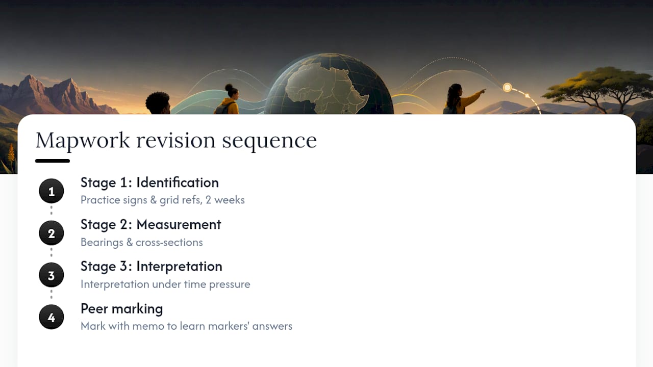
The research on Grade 12 mapwork performance in South Africa points to something specific: the gap is not effort, it is sequencing. Students who struggle most are those who were never forced to master Stage 1 (identification) before moving to measurement and interpretation. They can describe a contour pattern in general terms but cannot identify a specific conventional sign under time pressure. That identification failure then corrupts every downstream answer.
The practical fix is uncomfortable for teachers who feel pressure to cover content quickly: spend the first two weeks of any mapwork unit doing nothing but conventional signs and grid references. No bearings, no cross-sections. Just identification, repeated until it is automatic. The DBE teacher guidance supports this sequencing explicitly, and the university research on Grade 12 mapwork teaching confirms that scaffolded, staged practice outperforms general revision.
One more thing worth saying: peer marking with memos is underused. When students mark each other’s work against the official memo, they read the expected answer carefully, often for the first time. That single act teaches them more about what markers want than any amount of teacher explanation.
Past papers and memos for mapwork practice, free on Papersza
Papersza hosts a large collection of past exam documents from the DBE, IEB, and provincial authorities, all free to download with no account or registration. For Geography mapwork revision, the most direct route is the Geography past papers page, which organises papers by grade and exam session.

Senior learners should start with Grade 11 papers to consolidate foundational skills, then move to Grade 12 Geography papers and memos for matric-level exam practice. Every paper comes paired with a memo so you can mark your own work immediately and see the exact wording markers use. Teachers building differentiated practice sets can browse across grades from a single subject page. No subscription, no paywall, no sign-up form.
Authoritative sources for South African mapwork teaching
These are the primary resources teachers and students should use alongside past-paper practice:
- Department of Basic Education: Geography teacher guidance (mapwork)
- Maps and Geospatial Information — NGI
- TEACHING OF GEOGRAPHY MAPWORK IN GRADE 12 — University paper
- Official Practice Exam 1 — GISCI
- Senior Phase — Geography - Mapwork Skills Guide (CAPS Aligned) — Twinkl South Africa
- — YouTube
- PapersZA - South Africa’s Largest Independent Past-Paper Library
| Resource | Format | Best used for |
|---|---|---|
| NGI 1:50 000 topographic map | Print / digital raster | Exam extract practice, conventional signs |
| NGI 1:10 000 orthophoto | Digital raster | Linking symbols to real-world features |
| NGI DEM | Digital raster | Visualising elevation and contour patterns |
| DBE teacher guidance | Lesson planning, curriculum alignment | |
| Papersza Geography papers | PDF (free download) | Timed practice and memo-based self-marking |
This article provides general educational guidance. For official curriculum requirements and assessment standards, consult the DBE’s current CAPS documentation or your provincial education department directly.
FAQ
What are map skills in geography?
Map skills in geography are the practical abilities to read, measure, and interpret maps, including identifying conventional signs, calculating distances using scale, locating features with grid references, and drawing conclusions from contour patterns and spatial data.
What is mapwork in geography?
Mapwork is the examinable component of Geography that covers the technical reading and interpretation of topographic and other maps. In South Africa, it is a core part of the CAPS curriculum from Grade 7 through Grade 12, assessed by both the DBE and IEB.
What skills do you need for mapwork?
The core skills are: reading conventional signs and symbols, using scale to calculate distances, giving accurate grid references, calculating bearings, interpreting contours and relief, drawing cross-sections, and writing map-based interpretation answers with supporting evidence.
Where can I find past Geography mapwork papers for South African exams?
Papersza provides free access to DBE, IEB, and provincial Geography past papers and memos across Grades 7–12, with no account required. Grade 12 Geography papers are the recommended starting point for matric revision.
What types of questions appear in a Geography mapwork exam?
DBE and IEB mapwork questions typically include scale-conversion calculations, grid reference identification, bearing calculations, contour-based landform descriptions, map-based paragraph interpretation, and cross-section or sketch tasks.